Brampton Secondary Plans
Consolidating Policies
NRU
March 28, 2018
Dominik Matusik
Faced with a large number of outdated secondary plans, Brampton planners are proposing to consolidate them in an attempt to ensure their consistency with each other, and conformity to the city’s most recent official plan.
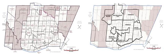
Currently, the City of Brampton is divided into 54 different secondary plan areas, some of which date to the 1970s. Staff is proposing to merge several plans together and reconfigure the boundaries of others to ensure consistency with and conformity to the city’s 2006 official plan.
Brampton policy planner Claudia LaRota said, in an email to NRU, that many of the city’s secondary plans refer to versions of the official plan that are long out-of-date.
“Many of Brampton’s secondary plans date back to the mid-1970s, when detailed policies about development phasing and provision of infrastructure were required,” she says. “Since these communities have been fully developed for some time now, these detailed policies are no longer relevant. In addition, the secondary plans reference previous versions of the city’s official plan, which means the documents are still in effect. This review ensures that policies are consistent with the 2006 official plan.”
LaRota explains that the consolidation is necessary to ensure that each secondary plan uses the same land use designations. Currently, these can vary between the plans, causing inconsistencies in land use policies.
“Many of the secondary plans have their own definitions of specific land use designations,” she says. “For example, a low-density residential designation does not permit the same density in every secondary plan; in many cases, it also doesn’t conform to the new housing mix and density categories of the official plan. As a result of this review, all land use designations will apply consistently to every secondary plan… In some cases, the name of the land use designation has changed (for example, industrial uses have become general employment), but the permitted uses and policies are the same.”
She adds that the secondary plans are being reorganized into larger areas that reflect their geography and community characteristics. The new secondary plan boundaries ensure that residential and employment areas are separated into different secondary plans.
LaRota stresses that this is not an exercise in conformity with the 2017 provincial Growth Plan. Rather, by virtue of the secondary plans being brought into conformity with Brampton’s 2006 official plan, they will only conform to the previous Growth Plan.
“As we are bringing the secondary plans into conformity with the 2006 official plan, they are being brought into conformity with the 2006 Growth Plan,” she says. “This is not a 2017 Growth Plan conformity exercise.”
Staff anticipates that council will adopt official plan amendments to consolidate the secondary plans by the end of 2018.
Below left: Map of Brampton’s existing 54 secondary plan areas.
Below right: Map of proposed consolidation of the city’s secondary plan areas.