Toronto's Housing Crisis: Impacts on Transportation & Transit
UrbanToronto.ca
March 20, 2017
Andrew Johnson
Late last week, my colleague wrote an article on the land use planning impacts of Toronto's housing crisis, examining both the supply and the demand factors that could be influencing the record prices. This article focuses primarily on the impacts that the unprecedented growth could have and is having on our transportation and transit infrastructure. The crux of the debate is the impact that growing outwards, and the type of outward growth that is taking place, has on our transportation infrastructure, compared to growing upwards.
Let's start with growing outwards. As my colleague mentioned, the Greenbelt is a common target of consternation from those who would like to see outward development continue. It has effectively placed a limit on how far municipalities can extend outwards into either farmland or natural areas. Beginning in the 1950s, surburban expansion in major North American cities, Toronto included, exploded. Most of this explosion was in the form of low-density, low-rise, single-detached housing.
Debating whether this low-density housing caused a depedence on the car, or whether the love affair with the car promoted this low-density housing, is a bit of a chicken and egg scenario. One thing is clear though: this pattern of suburban development decimated the viability of transit as a competitive option, ensuring that the private auto was pretty much the only viable transportation option available.
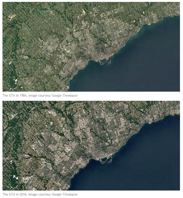
With an increase in private auto use comes demand for infrastructure to support that use. Thus begins the cycle of sprawl. We build low density development, then build the highways to service that development (as transit isn't a viable option), which in turn leads to a demand for more low density development, which in turn requires more highways to service it. And around and around the cycle goes, each time pushing further and further out. To see this in action, take a look at this time-lapse video, two images from which are below.

One of the key indicators of how far this sprawl has gone is the desire to construct "bypass" highways for the GTA. Highway 401 was originally referred to as the "Toronto Bypass", and at the time was built on the outskirts of Toronto. Today, in most places there is more development north of the 401 than there is south of it. The second bypass was Highway 407, which was originally conceived as a Provincially-owned and operated toll highway, intended to act as a bypass for the original bypass (the 401). In the time-lapse above, you can see it appear as a white ribbon across the top of the GTA in the early to mid 1990s.
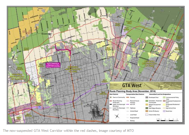
The third bypass conceived has been referred to in planning documents as the GTA West Corridor, sometimes referred to as Highway 413, though that designation has not been officially assigned yet by the MTO. The plan was to connect the 401-407 interchange with Highway 400 by going above the development fringes of Brampton and Vaughan, connecting with Highways 410 and 427 along the way. This route has been heavily criticized as promoting and being a potential catalyst for further sprawl, as well as passing through several environmentally sensitive areas. Work on the project was suspended by the Provincial government in December 2015.

So how do we build suburban areas that aren't forced to rely on the private auto? This brings us to growing upwards. Most of the post-war low-density development was in the density range of about 7-10 units per hectare. Research has shown that in order for a local bus route to be at least semi-viable the density needs to be at least 15 units per hectare, nearly double what the current average is. For a frequent bus service, the density needs to be at least 60 units per hectare. For a reference point, the shift in built form from houses (singles, semis, and towns) to apartments and condominiums is at about 25 units per hectare. With our suburban densities being as low as they are, the transit systems implemented in these areas either require substantial operating subsidies from the general tax base, or operate on schedules that are so infrequent that only those who absolutely need to use the service do so.
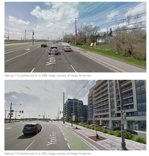
There has been an effort underway in the past decade or so to densify select corridors within what were traditionally low density suburban areas. This development has generally taken on two forms. The first a master-planned type of development where a corridor which has strategic transportation value but has seen little to no substantial development on it receives high density development. The best example of this in the GTA is Highway 7 in Richmond Hill and Markham. As the two images below show, there has been a substantial amount of development along that corridor in just the past 8 years (2009 to 2016), going from virtually farm land to 10+ storey condos and office buildings, as well as the introduction of the VIVA Highway 7 Rapidway, which brought rapid transit to this developing corridor.

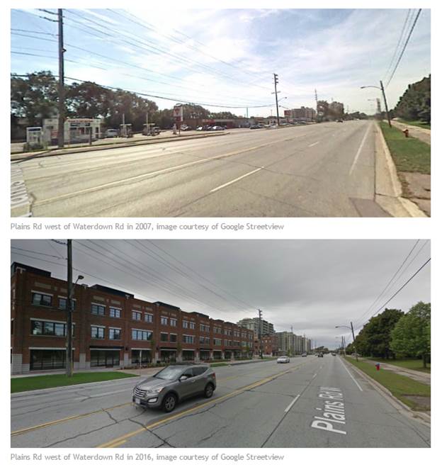
The second type of densification is more organic, and is generally taking place along corridors within existing built-up but low-rise areas. The City of Toronto has a plan to densify along what it refers to as 'avenues', called the Avenues and Midrise Buildings Study. This type of development is taking place in the 905 as well. Below are two images of Plains Rd in Burlington, which first saw commercial development in the 1950s, most of it in the form of motels and strip mall plazas. The images, taken in 2007 and 2016 respectively, show a transition from this 1950s style of development to mid-rise, mixed use development.

The third type of densification is an extension of the first, but rather than choosing a corridor on which to densify, some suburban municipalities are choosing to build new 'downtowns' from scratch. The largest and most successful example of this is the Mississauga City Centre. Located around the Square One shopping centre, Mississauga City Centre has exploded in both population and density since the late 1990s. Rapid transit was introduced to the area with the opening of the Mississauga Transitway in 2014, and the Hurontario LRT is planned to serve the area with a loop around the entire City Centre area.
Other examples of the 'downtown' model include Vaughan Metropolitan Centre, which will become the new northwestern terminus of the Yonge-University line when it opens later this year, Richmond Hill Centre, which is centred around the Langstaff GO Station and is the proposed terminus of the Yonge Subway extension, and Downtown Markham, which is largely centred around the Unionville GO Station.
These three types of examples show what is required in order to retrofit existing suburban areas to better support alternative transportation options, such as transit and cycling (it should be noted that in both of the corridor examples that dedicated cycling infrastructure was included). In order to avoid continuing the pattern of sprawl, these types of development will need to be embraced even further.
If the Greenbelt is allowed to be chipped away at piece by piece for the purpose of development, the never-ending cycle of sprawl and the construction of highways to support it as described earlier in the article will continue unabated. With the Greenbelt in place, developers are forced to utilize the land that is allowed to be developed more wisely, ultimately leading to more compact development that is more supportive of transit. Within the existing urban area, 'gentle' densification is needed to increase the efficiency of our existing transit services, and to further reduce the amount of development pressure placed on the urban fringe. Today, March 20th, the development industry is staging a coordinated lobby at Queens Park to push lawmakers to allow urban sprawl to extend into parts of the Greenbelt. If their request is granted, the end result will just be more of what we've seen for the past 60 years: the never-ending destructive cycle of sprawl will just keep on spinning.
